ThinkGeo Cloud
ThinkGeo UI Controls
ThinkGeo Open Source
Help and Support
External Resources
ThinkGeo Cloud
ThinkGeo UI Controls
ThinkGeo Open Source
Help and Support
External Resources
This is an old revision of the document!
The Map Suite Android Edition illustrated QuickStart Guide will guide you through the process of creating a sample application and will help you become familiar with Map Suite. This edition of the QuickStart Guide supports Android Edition 10.0.0 and higher and will show you how to create an Android application using Map Suite Android Edition.
If you want to build an iOS application using the standard Map Suite iOS Edition product, please see the iOS QuickStart Guide instead.
Welcome to Map Suite™ from ThinkGeo, a full-featured mapping control that makes it easy for any Microsoft .NET developer to add mapping functionality to a Microsoft .NET application quickly and efficiently. Using the intuitive object model, even developers inexperienced with Geographic Information Systems (GIS) can have fully functional maps working in minutes.
This guide will help you quickly get started building your own spatially aware applications. Like any new software, there will be some learning along the way.
How do we begin taking advantage of the power of Map Suite? The best way to learn is to make a sample application with it.
Please follow our Android Edition Installation Guide for Xamarin Android development environment.
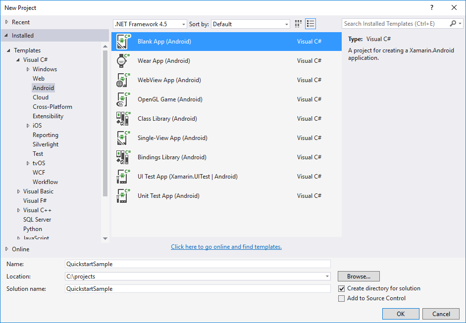
Let's start by creating a new Android project in Microsoft Visual Studio (2012 or newer) named HelloWorld (see Figure 1). We can create the project with .NET Framework 4.5.

Figure 1. Creating a new project in the Visual Studio IDE.
The project HelloWorld is created in a new solution called HelloWorld. The wizard creates a single Android Application. Choose Android version (4.0.3 or higher) for the project:
Now we are going to install MapSuite Mobile for iOS NuGet package. Let's open NuGet Manager dialog and install following three NuGet packages.

Figure 2. Open NuGet Manager UI in the Visual Studio IDE.

Figure 3. Install Android Package.

Figure 4. Install Shapefile Package.
Next we need to prepare our map data. There are two ways to copy data to phone or tablet. The first way is using android ddms tool. We can find the tool under “[android-sdk]\tools\ddms.bat”.
Open the tool, and use File Explorer to add data.
Create a new folder under sdcard named “Android Sample”.
Next, create a new folder named “GetStarted” under “Android.Sample”, and push these files onto Device:
The second way to copy data to phone or tablet is by using code. Create a new folder named AppData under “Assets”, then add the map data to it. Make sure the resources’ build action is AndroidAsset.
Then we can use code to copy data to a special location. There are two kinds of data paths:
One is under our application, like “/data/data/HelloWorld.HelloWorld/AppData/”.
The other one is under the sdcard, like “/mnt/sdcard/Android.Sample/GetStarted/”.
protected override void OnCreate(Bundle bundle)
{
    base.OnCreate(bundle);
    SetContentView(Resource.Layout.Main);

    // Copy the required Shapefiles to Device.
    string targetDirectory = (@"/mnt/sdcard/Android.Sample/GetStarted/");
    CopySampleData(targetDirectory);
}
This method will copy data to the target path, if the folder does not exist.
private void CopySampleData(string targetDirectory)
{
	if (!Directory.Exists(targetDirectory))
	{
		Directory.CreateDirectory(targetDirectory);
		foreach (string filename in Assets.List("AppData"))
		{
			Stream stream = Assets.Open("AppData/" + filename);
			FileStream fileStream = File.Create(Path.Combine(targetDirectory, filename));
			stream.CopyTo(fileStream);
			fileStream.Close();
			stream.Close();
		}
	}
}
We are going to add more project
Note: Although it is not a ThinkGeo assembly, you also need to add “System.Windows.dll ” to the references. System.Windows can be found on the .NET tab of the Add Reference dialog. If you don't do this, you will get the following error when you compile the project:“The type 'System.Collections.Specialized.INotifyCollectionChanged' is defined in an assembly that is not referenced. You must add a reference to assembly 'System.Windows, Version=2.0.5.0, Culture=neutral, PublicKeyToken=7cec85d7bea7798e, Retargetable=Yes'.”
Open the Resources\layout\Main.axml file. Remove the default button node, and insert MapView node in the axml.
<?xml version="1.0" encoding="utf-8"?>
<LinearLayout xmlns:android="http://schemas.android.com/apk/res/android"
    android:orientation="vertical"
    android:layout_width="fill_parent"
    android:layout_height="fill_parent">
    <ThinkGeo.MapSuite.Android.MapView
        android:id="@+id/MapView"
        android:layout_width="fill_parent"
        android:layout_height="fill_parent"/>
</LinearLayout>
Now we have our “AndroidEdition.dll” and “MapSuitePortableCore.dll” referenced and a MapView added.
After completing this section, we'll be able to draw a map with the MapView using our own data. First, let's have a look at the data and the important objects we'll use.
The first step in creating our “Hello World” sample application is to set references to the ThinkGeo.MapSuite, ThinkGeo.MapSuite.Android and ThinkGeo.MapSuite.Shapes namespaces at the very top of our code, since we'll use many classes within them. Set the reference like this:
using ThinkGeo.MapSuite;
using ThinkGeo.MapSuite.Android;
using ThinkGeo.MapSuite.Shapes;
Now the project is ready, Map Suite Runtime license is required for running and debugging your product. Please open the Product Center, then generate your license by steps like login account → activate or start evaluation → continue debugging → get runtime license. For more details, please refer to (http://wiki.thinkgeo.com/wiki/map_suite_runtime_license_guide_for_mobile).
Now, Let's add a base overlay to display the world map witch called “WorldStreetsAndImageryOverlay”.
protected override void OnCreate(Bundle bundle)
{
    base.OnCreate(bundle);
    SetContentView(Resource.Layout.Main);

    // Get MapView From Activity's View.
    MapView mapView = FindViewById<MapView>(Resource.Id.MapView);

    // Set the Map Unit to DecimalDegrees, the Shapefile’s unit of measure.
    mapView.MapUnit = GeographyUnit.DecimalDegree;

    // Create a WorldStreetsAndImageryOverlay.
    WorldStreetsAndImageryOverlay worldStreetsAndImageryOverlay = new WorldStreetsAndImageryOverlay();

    // Add a WorldStreetsAndImageryOverlay .
    mapView.Overlays.Add("WorldStreetsAndImageryOverlay", worldStreetsAndImageryOverlay);

    // Set a proper extent for the map. The extent is the geographical area you want it to display.
    mapView.CurrentExtent = new RectangleShape(5, 78, 30, 26);
}
If we compile and run what we have now, our map should look like the one below. (see Figure 3).
Now let's look at a code sample to bring this concept to fruition. We'll look at Shapefiles relating to the entire world. In our example, we have one such Shapefile:
(NOTE: The data used here can be found in the attached sample above at “\Assets\AppData” folder. The data files' build action should be “AndroidAssets”.)
Our next step is to define and add our layers. All of our sample code is placed in the OnCreate method of the MainActivity.cs. So our MapView can load and render the data, we can add logic to check the data to avoid coping it every time.
protected override void OnCreate(Bundle bundle)
{
    base.OnCreate(bundle);
    SetContentView(Resource.Layout.Main);

    // Copy the required shapefiles to Device.
    string targetDirectory = (@"/mnt/sdcard/Android.Sample/GetStarted/");
    CopySampleData(targetDirectory);

    MapView mapView = FindViewById<MapView>(Resource.Id.MapView);
    mapView.MapUnit = GeographyUnit.DecimalDegree;

    // Create a WorldStreetsAndImageryOverlay.
    WorldStreetsAndImageryOverlay worldStreetsAndImageryOverlay = new WorldStreetsAndImageryOverlay();

    // Add a WorldStreetsAndImageryOverlay .
    mapView.Overlays.Add("WorldStreetsAndImageryOverlay", worldStreetsAndImageryOverlay);

    // We create a new Layer and pass the path to a Shapefile into its constructor.
    ShapeFileFeatureLayer worldLayer = new ShapeFileFeatureLayer(Path.Combine(targetDirectory, "cntry02.shp"));

    // Set the worldLayer with a preset Style, as AreaStyles.Country1 has a YellowGreen background and black border, our worldLayer will have the same render style.
    worldLayer.ZoomLevelSet.ZoomLevel01.DefaultAreaStyle = AreaStyles.Country1;

    // This setting will apply from ZoomLevel01 to ZoomLevel20, which means the map will be rendered with the same style no matter how far we zoom in or out.
    worldLayer.ZoomLevelSet.ZoomLevel01.ApplyUntilZoomLevel = ApplyUntilZoomLevel.Level20;

    // We need to create a LayerOverlayer to add the world layer.
    LayerOverlay overlay = new LayerOverlay();
    overlay.Opacity = 0.8;
    overlay.Layers.Add(worldLayer);

    mapView.Overlays.Add("Countries02", overlay);

    mapView.CurrentExtent = new RectangleShape(5, 78, 30, 26);
}
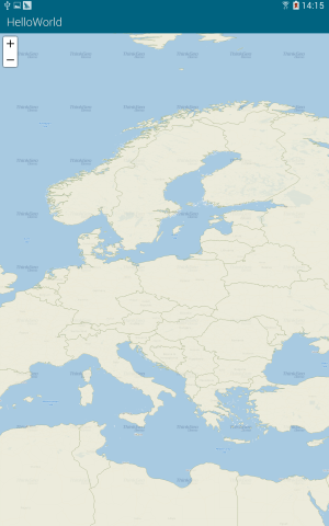
If we compile and run what we have now, our map should look like the one below. (see Figure 4).

Figure 4. A simple map of Europe.
So what has occurred here? We've created a layer and added it to the Map, and the Map has rendered it according to its default style parameters. We've also used ZoomLevel to display the map the way we want.
NOTE: It is important that the MapUnit property of a Map object be set using the GeographyUnit Enumeration. This is because the coordinates stored in a Shapefile can be in decimal degrees (a format of latitude and longitude), feet, meters, or another unit system, and our map has no way to know what the Shapefile's unit of measurement is until we tell it. This information is normally found somewhere in the Shapefile's documentation (also referred to as its metadata), or within its supplemental data file, as discussed in the section on Shapefiles. It may also come as a separate .txt, .xml, or .html file that begins with the same file name as the main Shapefile.
Now you can display and navigate your map. Pan by dragging the map, zoom in by double-clicking, track zoom in by drawing a rectangle with your left mouse button mouse while holding the shift key, or zoom in and out with the mouse wheel. Very powerful for just couple lines of code, isn't it?
That was an easy start! Now let's add a second Shapefile to the sample, so we'll have a total of two layers:
protected override void OnCreate(Bundle bundle)
{
    base.OnCreate(bundle);
    SetContentView(Resource.Layout.Main);

    string targetDirectory = (@"/mnt/sdcard/Android.Sample/GetStarted/");
    CopySampleData(targetDirectory);

    MapView mapView = FindViewById<MapView>(Resource.Id.MapView);
    mapView.MapUnit = GeographyUnit.DecimalDegree;

    // Create a WorldStreetsAndImageryOverlay.
    WorldStreetsAndImageryOverlay worldStreetsAndImageryOverlay = new WorldStreetsAndImageryOverlay();

    // Add a WorldStreetsAndImageryOverlay .
    mapView.Overlays.Add("WorldStreetsAndImageryOverlay", worldStreetsAndImageryOverlay);

    ShapeFileFeatureLayer worldLayer = new ShapeFileFeatureLayer(Path.Combine(targetDirectory, "cntry02.shp"));
    worldLayer.ZoomLevelSet.ZoomLevel01.DefaultAreaStyle = AreaStyles.Country1;
    worldLayer.ZoomLevelSet.ZoomLevel01.ApplyUntilZoomLevel = ApplyUntilZoomLevel.Level20;

    // Similarly, we use the presetPointStyle for cities.
    ShapeFileFeatureLayer capitalLayer = new ShapeFileFeatureLayer(Path.Combine(targetDirectory, "capital.shp"));

    // These settings will apply from ZoomLevel01 to ZoomLevel20, which means city symbols will be rendered in the same style, no matter how far we zoom in or out.
    capitalLayer.ZoomLevelSet.ZoomLevel01.DefaultPointStyle = PointStyles.Capital3;

    // We need to add both of the new layers to the Map's Static Overlay.
    capitalLayer.ZoomLevelSet.ZoomLevel01.ApplyUntilZoomLevel = ApplyUntilZoomLevel.Level20;

    // We need to create a LayerOverlayer to add the world layer.
    LayerOverlay overlay = new LayerOverlay();
    overlay.Opacity = 0.8;
    overlay.Layers.Add(worldLayer);
    overlay.Layers.Add(capitalLayer);

    mapView.Overlays.Add("Countries02", overlay);

    mapView.CurrentExtent = new RectangleShape(5, 78, 30, 26);
}
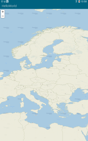
And the result is as following (Figure 5):

Figure 5. A map of Europe with the additional borders and capitals layers displayed.
TextStyle is used to label items on map. While the features themselves are drawn from information in the Shapefile, they're labeled with feature names or other attributes contained in the .dbf file. For example, the Shapefile containing capitals of the world has a corresponding .dbf file with the field “CITY_NAME”. We can use this field to label the cities on our map.
Map Suite includes several built-in TextStyles to help us quickly apply attractive city labels. We can simply pick the TextStyle we like and use it.
protected override void OnCreate(Bundle bundle)
{
    base.OnCreate(bundle);
    SetContentView(Resource.Layout.Main);

    string targetDirectory = (@"/mnt/sdcard/Android.Sample/GetStarted/");
    CopySampleData(targetDirectory);

    MapView mapView = FindViewById<MapView>(Resource.Id.MapView);
    mapView.MapUnit = GeographyUnit.DecimalDegree;

    WorldStreetsAndImageryOverlay worldStreetsAndImageryOverlay = new WorldStreetsAndImageryOverlay();
    mapView.Overlays.Add("WorldStreetsAndImageryOverlay", worldStreetsAndImageryOverlay);

    ShapeFileFeatureLayer worldLayer = new ShapeFileFeatureLayer(Path.Combine(targetDirectory, "cntry02.shp"));
    worldLayer.ZoomLevelSet.ZoomLevel01.DefaultAreaStyle = AreaStyles.Country1;
    worldLayer.ZoomLevelSet.ZoomLevel01.ApplyUntilZoomLevel = ApplyUntilZoomLevel.Level20;

    ShapeFileFeatureLayer capitalLayer = new ShapeFileFeatureLayer(Path.Combine(targetDirectory, "capital.shp"));
    capitalLayer.ZoomLevelSet.ZoomLevel01.DefaultPointStyle = PointStyles.Capital3;
    capitalLayer.ZoomLevelSet.ZoomLevel01.ApplyUntilZoomLevel = ApplyUntilZoomLevel.Level20;

    // We create a new Layer for labeling the capitals.
    ShapeFileFeatureLayer capitalLabelLayer = new ShapeFileFeatureLayer(Path.Combine(targetDirectory, "capital.shp"));
    // We use the preset TextStyle. Here we pass in the “CITY_NAME”, the name of the field containing the values we want to label the map with.
    capitalLabelLayer.ZoomLevelSet.ZoomLevel01.DefaultTextStyle = TextStyles.Capital3("CITY_NAME");
    capitalLabelLayer.ZoomLevelSet.ZoomLevel01.ApplyUntilZoomLevel = ApplyUntilZoomLevel.Level20;
    // As the map is drawn by tiles, it needs to draw on the margin to make sure the text is complete after joining the tiles together.
    // Change the number below (to 0, for example) to better understand how this works.
    capitalLabelLayer.DrawingMarginPercentage = 50;

    LayerOverlay overlay = new LayerOverlay();
    overlay.Opacity = 0.8;
    overlay.Layers.Add(worldLayer);
    overlay.Layers.Add(capitalLayer);
    // Add the label layer to LayerOverlay.
    overlay.Layers.Add(capitalLabelLayer);

    mapView.Overlays.Add("Countries02", overlay);

    mapView.CurrentExtent = new RectangleShape(5, 78, 30, 26);
}
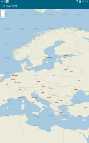
The result is as follows (Figure 6):

Figure 6. Europe map with TextStyle applied.
Now that we know how to render text and symbols, let's create custom Styles and TextStyles. We'll also specify different ranges of ZoomLevels, and apply varying custom Styles and TextStyles to the same layer at different ZoomLevel ranges.
protected override void OnCreate(Bundle bundle)
{
    base.OnCreate(bundle);
    SetContentView(Resource.Layout.Main);

    string targetDirectory = (@"/mnt/sdcard/Android.Sample/GetStarted/");
    CopySampleData(targetDirectory);

    MapView mapView = FindViewById<MapView>(Resource.Id.MapView);
    mapView.MapUnit = GeographyUnit.DecimalDegree;


    WorldStreetsAndImageryOverlay worldStreetsAndImageryOverlay = new WorldStreetsAndImageryOverlay();
    mapView.Overlays.Add("WorldStreetsAndImageryOverlay", worldStreetsAndImageryOverlay);

    ShapeFileFeatureLayer worldLayer = new ShapeFileFeatureLayer(Path.Combine(targetDirectory, "cntry02.shp"));
    worldLayer.ZoomLevelSet.ZoomLevel01.DefaultAreaStyle = AreaStyles.Country1;
    worldLayer.ZoomLevelSet.ZoomLevel01.ApplyUntilZoomLevel = ApplyUntilZoomLevel.Level20;

    ShapeFileFeatureLayer capitalLayer = new ShapeFileFeatureLayer(Path.Combine(targetDirectory, "capital.shp"));
    // We can customize our own Style. Here we pass in a color and size.
    capitalLayer.ZoomLevelSet.ZoomLevel01.DefaultPointStyle = PointStyles.CreateSimpleCircleStyle(GeoColor.StandardColors.White, 7, GeoColor.StandardColors.Brown);
    // The Style we set here is available from ZoomLevel01 to ZoomLevel05. That means if we zoom in a bit more, it will no longer be visible.
    capitalLayer.ZoomLevelSet.ZoomLevel01.ApplyUntilZoomLevel = ApplyUntilZoomLevel.Level05;

    capitalLayer.ZoomLevelSet.ZoomLevel06.DefaultPointStyle = PointStyles.Capital3;
    // The Style we set here is available from ZoomLevel06 to ZoomLevel20. That means if we zoom out a bit more, it will no longer be visible.
    capitalLayer.ZoomLevelSet.ZoomLevel06.ApplyUntilZoomLevel = ApplyUntilZoomLevel.Level20;

    ShapeFileFeatureLayer capitalLabelLayer = new ShapeFileFeatureLayer(Path.Combine(targetDirectory, "capital.shp"));
    // We can customize our own TextStyle. Here we pass in the font, size, style and color.
    capitalLabelLayer.ZoomLevelSet.ZoomLevel01.DefaultTextStyle = TextStyles.CreateSimpleTextStyle("CITY_NAME", "Arial", 8, DrawingFontStyles.Italic, GeoColor.StandardColors.Black, 3, 3);
    // The TextStyle we set here is available from ZoomLevel01 to ZoomLevel05.
    capitalLabelLayer.ZoomLevelSet.ZoomLevel01.ApplyUntilZoomLevel = ApplyUntilZoomLevel.Level05;

    capitalLabelLayer.ZoomLevelSet.ZoomLevel06.DefaultTextStyle = TextStyles.Capital3("CITY_NAME");
    // The TextStyle we set here is available from ZoomLevel06 to ZoomLevel20.
    capitalLabelLayer.ZoomLevelSet.ZoomLevel06.ApplyUntilZoomLevel = ApplyUntilZoomLevel.Level20;

    capitalLabelLayer.DrawingMarginPercentage = 50;

    LayerOverlay overlay = new LayerOverlay();
    overlay.Opacity = 0.8;
    overlay.Layers.Add(worldLayer);
    overlay.Layers.Add(capitalLayer);
    // Add the label layer to LayerOverlay.
    overlay.Layers.Add(capitalLabelLayer);

    mapView.Overlays.Add("Countries02", overlay);

    mapView.CurrentExtent = new RectangleShape(5, 78, 30, 26);
}
Can you imagine what the map will look like now? Below is the result. At first it looks like Figure 7, then like Figure 8 as you zoom in further.
You now know the basics of using the Map Suite Map control and can start adding this functionality to your own applications. Let's recap what we've learned about the object relationships and how the pieces of Map Suite work together: